300+ Lots On 1,300+ Acres in 21 New Subdivisions
In 2023, public hearings covering 21 'pending' subdivisions headed to Teton Valley. These subdivision proposals were all in different phases of the application process - and most coming from the mad dash of applications sliding in before the new Code was adopted.
Some updates for the 2000 S area and other larger developments as of May 2024:
HILLMAN FARM • 47 LOTS/157ACRES - Preliminary Plat Hearing 6/12/24
GREYSTONE • 9 LOTS/40 ACRES - Preliminary Plat Hearing 6/11/24
FREE RANCH • 63 LOTS/159 ACRES - Concept Hearing - WITHDRAWN
HIDDEN OAKS • 60 LOTS/267 ACRES - Concept Hearing - DENIED
TRESTLES • 44 LOTS/136 ACRES - DENIED
WILDFLOWER • 24 LOTS/65 ACRES - DENIED
LANCIN • 8 LOTS/20 ACRES - APPROVED/COMPLETE
If it seems like a lot, it's because it is! In 2023, public hearings covering 21 'pending' subdivisions headed to Teton Valley. These subdivision proposals were all in different phases of the application process - and most coming from the mad dash of applications sliding in before the new Code was adopted. These hearings served as an opportunity for our community to weigh in.
Below is a list of public hearings by date. Click a subdivision name to view available application materials.
Applications Listed by Hearing Dates
BOARD OF COUNTY COMMISSIONERS PUBLIC HEARINGS
January 9, 2023 @ 1:00 PM
150 Courthouse Dr, Driggs, ID 83422 1st Floor Meeting Room
You can attend & give comments in person at the hearing, and/or
Email comments to: commissioners@co.teton.id.us
Comment and watch online: Zoom Link
GREENBACK • 6 LOTS/40 ACRES - PRELIMINARY PLAT HEARING - Staff Report
This parcel was zoned A/RR 2.5 - when owner submitted application under old code (now LA-35 Lowland Agriculture) - and is located in the Priority Wetland Habitat Overlay, Big Game Migration Corridors and Seasonal Range, and the Songbird/Raptor Breeding and Wintering Habitat. The property also includes land, in the northwest corner, indicated as potential floodplain on the draft floodplain map.
LAUREL FLATS • 4 LOTS/18 ACRES - PRELIMINARY PLAT HEARING - Staff Report
This parcel is located off of W 9500 S and the lots will meet County zoning size requirements and range from 2.5 – 5.8 acres. The project is located in the Victor Area of Impact, AOI-2.5, Area of Impact Zone. There are no overlay areas.
ELLES ASPENS • 2 LOTS/79 ACRES - FINAL PLAT HEARING - Staff Report
Lot split located on W 5500 N and N 7000 W south west of the City of Tetonia. The parcel was zoned - when owner submitted application - Agriculture, 20-acre min lot size (now RA-35 Rural Agriculture). It is within the Big Game Migration & Seasonal Habitat Overlay.
CROSSED ARROWS • 5 LOTS/119 ACRES - FINAL PLAT HEARING - Staff Report
This parcel is located north west of the City of Driggs and South of the City of Tetonia, bordering the Cache Townsite. The zoning is Agriculture - 20-Acre and the lots range from 20 - 30 acres in size. There is a Priority Wetland Habitat overlay on the parcel.
PLANNING & ZONING COMMISSION PUBLIC HEARINGS
January 17, 2023 @ 5:00 PM
150 Courthouse Dr, Driggs, ID 83422 1st Floor Meeting Room
You can attend & give comments in person at the hearing, and/or
Email comments to: pz@co.teton.id.us
Comment and join online: Zoom Link
SUNSET ESTATES • 3 LOTS/18 ACRES - PRELIMINARY PLAT HEARING
Located approximately 2 miles North of Victor near 5500 S. Application is for a 3 lot subdivision on vacant land in what is now zoned RN-5, Rural Neighborhood. There are no overlay areas on the parcel.
STRAWBERRY ROAN • 2 LOTS/17 ACRES - PRELIMINARY PLAT HEARING
Lot Split, located approximately half way between Driggs and Victor on 4000 S Application for a 2 lot subdivision of 17.67 acres located on 4000 S - 9.67 and 8.00 acres - which meet the old County zoning requirements of A/RR 2.5 (now RN-5, Rural Neighborhood). There are no overlay areas on the parcel.
ALBANESE PUD • 3 LOTS/20 ACRES - PRELIMINARY PLAT HEARING - Staff Report
Proposed residential subdivision located off of Packsaddle Road on the west side of the Valley. The site was zoned A-20 when the application was submitted and is now zoned RA-35, Rural Agriculture. The proposed development consists of 3 lots developed as a rural reserve PUD in accordance with Teton County Subdivision Regulations with two five-acre lots intended for residential development and one ten-acre lot designated as open space. The site is located in a Natural Resource Overlay with critical habitat for big game migration. A portion of the property falls within the Hillside (HS) Overlay; therefore, a specific contour plan and grading plan may be required along with a soils report, slope stabilization and revegetation plan, and building envelope location map relevant to the HS Overlay. Also located in the Wildfire Hazard Overlay.
KRASK • 15 LOTS/40 ACRES - CONCEPT HEARING
Proposed residential subdivision located approximately one mile north of the City of Driggs in Teton County, Idaho. The zoning - when owner submitted application ONE DAY BEFORE the new code - was A / RR 2.5 (now RN-5, Rural Neighborhood). There are no overlay areas on the parcel.
MAPLE BELLA • 4 LOTS/26 ACRES - CONCEPT HEARING
The parcel was zoned Agriculture, 20-acre min lot size, when the application was submitted. The parcel is located in the Priority Wetland Habitat Overlay. The Priority Wetland Habitat overlay is mapped over approximately 32.4 acres that bisects the parent parcel. The Applicant has begun the process of analyzing whether the area is considered a jurisdictional wetland. Preliminary findings have not yet been made.
HILLMAN FARM • 47 LOTS/157ACRES - CONCEPT HEARING
Proposed residential subdivision located approximately 1 mile from the City of Driggs off HWY33. The site was zoned A/RR-2.5 - when owner submitted application under old code (now RR-20, Rural Residential.) The proposed development consists of 47 residential lots with a minimum lot size of 2.5 acres. There are no overlay areas on the parcel.
BOARD OF COUNTY COMMISSIONERS PUBLIC HEARINGS
January 23, 2023 STARTING AT 1:00 PM
150 Courthouse Dr, Driggs, ID 83422 1st Floor Meeting Room
You can attend & give comments in person at the hearing
Email comments to: commissioners@co.teton.id.us
Check the agenda or email us for Zoom details.
CENTENNIAL ESTATES • 15 LOTS/70 ACRES - FINAL PLAT HEARINGS
The proposed subdivision is located off of 2000 E, about 0.7-mile north of 5000 S (Fox Creek Road). The parcel was zoned A / RR 2.5 when the applicant submitted - it's now RN-5, Rural Neighborhood. A portion in the southeast corner of the development is within defined Big Game Migration Corridor and Seasonal Range. Concerns over traffic and road maintenance with more people and construction vehicles are being raised.
COTTONWOOD RANCHES DIV 11 • 14 LOTS/40 ACRES
Located near W2000N and Stateline Road The parcel was zoned A / RR 2.5 when the applicant submitted - it's now RN-5, Rural Neighborhood. No overlay areas.
FEB 14, 2023 - TETON COUNTY PLANNING & ZONING PUBLIC HEARINGS
More info to come....
Free Ranch • 63 LOTS/159 ACRES - Concept Hearing
Hidden Oaks • 60 LOTS/267 ACRES - Concept Hearing
Bowen Arrow • 7 LOTS/40 ACRES - Preliminary Plat Hearing
Greystone • 9 LOTS/40 ACRES - Preliminary Plat Hearing
Homestead Ranches • 2 LOTS/79 ACRES - Preliminary Plat Hearing
Lancin • 8 LOTS/20 ACRES - Preliminary Plat Hearing
Wildspring Ranch • 6 LOTS/40 ACRES - Preliminary Plat Hearing
FEB 27, 2023 - TETON COUNTY PLANNING & ZONING PUBLIC HEARINGS
LUCY MEADOWS • 30 Lots/80 Acres - Final Plat Hearings
WINTERFEST • 2 Lots/13 Acres - Final Plat Hearings
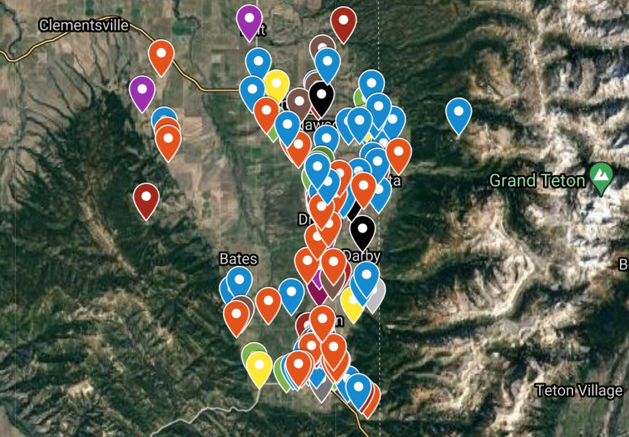
Visit our website to view the development map where we track all these subdivisions.


