To Sprawl or Not to Sprawl?
February, 16 2021
Categories:
Your Voice is Needed to Chart the Course for Victor
Last month, the City of Victor Planning & Zoning Commission substantively changed the draft Future Land Use Map (FLUM) to allow for more greenspace at the city's edges. While this is generally a good change, the FLUM is still fundamentally flawed. It seeks to increase the physical footprint of Victor by around 40%, while Victor’s population is only expected to increase by 8%. Moreover, Victor has over 400 vacant lots and other developable lands within the city’s existing footprint. There is so much vacant land, that by our calculations, the city could accommodate thousands of new residents if it were to simply re-draw city boundaries around existing development and fill its vacant lots and parcels.
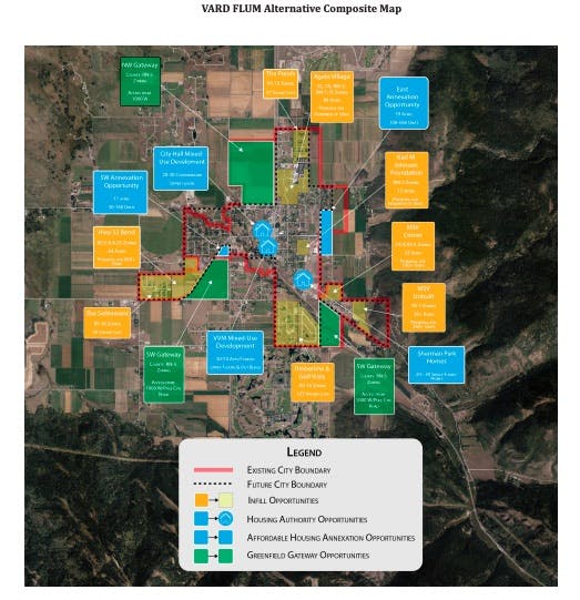
VARD created our own version of the FLUM (click below to view in detail) which demonstrates this. In our FLUM, the City of Victor could draw tight boundaries around its existing physical footprint, and still there would be the potential to build thousands of residential units.

Not only does our FLUM ensure that Victor fills up and becomes more vibrant, but it means that we protect the beautiful farmlands and wildlife habitat that the City proposed to develop.
And here’s why that’s important: Teton Valley is in the Greater Yellowstone Ecosystem (GYE), the planet’s ONLY intact ecosystem in a temperate zone. Our duty is profound; before we expand our human footprint, we have to make sure that we have exhausted all other options. Sprawling in Idaho Falls or Salt Lake City means the loss of farmland and rural character. But in Teton Valley, if we sprawl, we also take an irreversible whack at something that exists nowhere else on the planet.
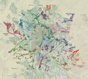
Consider the GYE elk herds shown in this map below. This map is the result of an on-going elk-collaring effort led by a partnership between Idaho Fish and Game Department, the Middleton Lab at the University of California-Berkeley, and the Wyoming Game and Fish Department.

As you can see, the Targhee herd has several segments in Teton Valley, and we are just now learning about this “enigmatic” herd. The herd segment east of Driggs is well-known, and efforts like the Teton Creek Corridor Project have been created specifically to nurture this part of the herd for long-term sustainability. Then you have the Victor segment of the herd, and, as you can see, they come very close to the city. As you may know, elk are very sensitive to human presence, particularly in winter where conflicts with people and pets can have real impacts on their survival. Elk need security to buffer them from human activities so they can survive winter; sprawl into winter habitats chips away at that security and can ultimately mark the end of a herd segment. This is true of moose, deer, and other big game.
VARD’s map allows the city to flourish but also protects our globally significant ecosystem. It is the best of both worlds. Lands outside of the city then can be governed by the county, which is proposed as 5-acre, 10, 20, or 35-acre zoning with enhanced wildlife protections.
What can you do?
Do you agree with VARD’s vision? If you do, now is the time to let Victor City Council know (email planner@victorcityidaho.com) . Simply tell them you agree with VARD's vision and/or submit your own specific thoughts. As you know, Teton Valley is one community; we cannot place ourselves into arbitrary government silos when issues like rural character and environmental stewardship are regional in nature. So, if you live in Victor, or the County, or Driggs, or wherever, make your voice heard. Let us harmonize various community planning efforts into a shared vision of sustainable environment, agricultural heritage, and compact, vibrant cities.
Stay informed on Teton Valley's important projects
Get the latest news in your inbox